
In the first year, SCALE researchers will sample over 100 lakes throughout the Adirondacks. Most of these lakes will receive a single visit (low intensity sampling) to characterize broad spatial patterns across the region (low year 1 in the map below shows the first set of 100 low intensity lakes selected). Twenty lakes will be sampled at a higher intensity, with visits every few weeks throughout the year. In addition to multiple manual samples, these lakes will also have high frequency sensors installed, allowing us to record temperature, oxygen, and weather patterns continuously.
Of these twenty lakes ten will be monitored continuously over the three-year period of SCALE (high 3 year in the map below). Each year, the second ten will be swapped for a new set of ten lakes to be intensively sampled. Ultimately we will have high intensity sampling completed on 40 lakes.
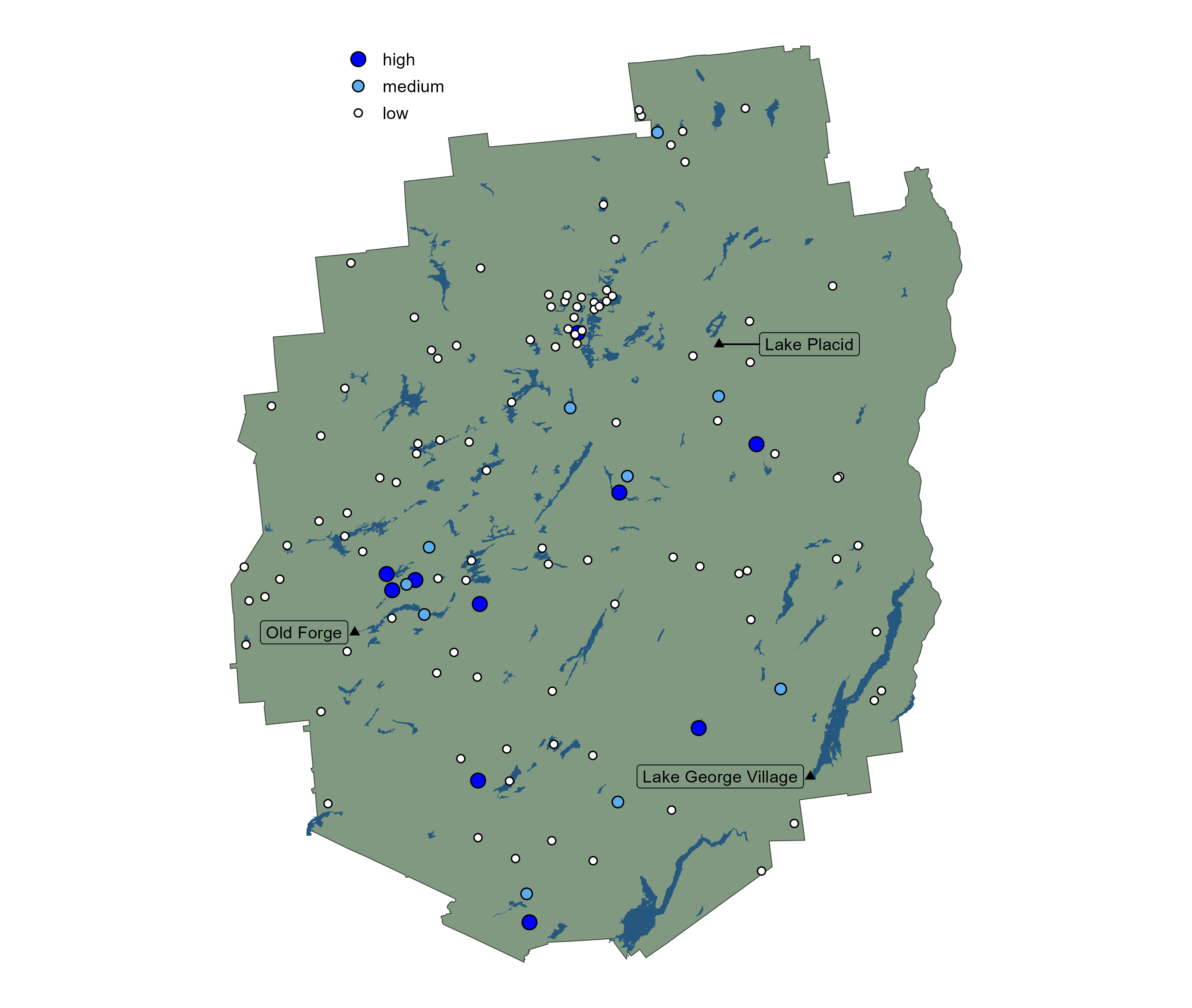
The high intensity lakes are:
| Lake Name | Pond Number | Latitude | Longitude |
|---|---|---|---|
| UPPER AUSABLE LAKE | 020277 | 44.07782 | -73.8728 |
| SQUASH POND | 040754 | 43.82654 | -74.8873 |
| DART LAKE | 040750 | 43.79604 | -74.8627 |
| G LAKE | 070859 | 43.41387 | -74.6321 |
| WEST CAROGA LAKE | 070698 | 43.13308 | -74.4897 |
| QUEER LAKE | 060329 | 43.81108 | -74.7985 |
| SAGAMORE LAKE | 060313 | 43.76795 | -74.6193 |
| LITTLE ECHO POND | 020126 | 44.30579 | -74.3573 |
| GARNET LAKE | 050520 | 43.52536 | -74.023 |
| ARBUTUS LAKE | 050684 | 43.98786 | -74.2417 |
The first year medium intensity lakes include:
| Lake Name | Pond Number | Latitude | Longitude |
|---|---|---|---|
| HEART LAKE | 020264 | 44.18261 | -73.9689 |
| WINDFALL POND | 040750A | 43.80539 | -74.8288 |
| UPPER SISTER LAKE | 040769 | 43.87933 | -74.7663 |
| SIXTH LAKE FULTON CHAIN | 040787A | 43.74685 | -74.7432 |
| OTTER LAKE | 070729 | 43.18839 | -74.4989 |
| FOLLENSBY POND | 060186 | 44.17363 | -74.3751 |
| WILLIS LAKE | 050215 | 43.36901 | -74.2415 |
| MOUNTAIN VIEW LAKE | 030050 | 44.69875 | -74.1268 |
| WOLF LAKE | 050588 | 44.02058 | -74.2197 |
| TRIPP LAKE | 050358 | 43.59666 | -73.7953 |
And the first year low intensity lakes include:
| Lake Name | Pond Number | Latitude | Longitude |
|---|---|---|---|
| CRANBERRY POND | 030314 | 44.4455 | -74.9851 |
| FISHPOLE POND | 030033 | 44.73776 | -74.1828 |
| BRADLEY POND | 030007 | 44.75307 | -73.8877 |
| DOYLE POND | 020309B | 44.3972 | -73.6528 |
| NICKS LAKE | 040804 | 43.67768 | -74.9925 |
| FISHBROOK POND | 020407 | 43.57566 | -73.5375 |
| BRANTINGHAM LAKE | 040689 | 43.69535 | -75.2744 |
| CRYSTAL LAKE | 040595 | 43.83897 | -75.2752 |
| SQUARE POND | 020125 | 44.30362 | -74.3697 |
| FOLLENSBY CLEAR POND | 020116 | 44.32186 | -74.347 |
| SHALLOW LAKE | 060324 | 43.81836 | -74.736 |
| HOEL POND | 020161 | 44.35277 | -74.3502 |
| TROUT POND | 060146 | 44.09544 | -74.6404 |
| HELLDIVER POND | 040877 | 43.66877 | -74.6966 |
| GRASS POND | 030156 | 44.37917 | -74.3477 |
| DEER POND | 050242 | 43.47768 | -74.5534 |
| NORTH POND | 040615 | 43.78117 | -75.222 |
| SOUTH OTTER POND | 030159 | 44.36653 | -74.3132 |
| LONG POND #3 | 020158 | 44.3701 | -74.3931 |
| MIKES POND | 040631 | 43.81579 | -75.1817 |
| LAPLAND POND | 020400 | 43.59523 | -73.5181 |
| CRYSTAL LAKE | 040289 | 44.10187 | -75.0684 |
| UNNAMED POND | 040851 | 43.62824 | -74.7494 |
| ALFORD POND | 020096 | 44.26151 | -74.0366 |
| ST. GERMAIN POND | 020201 | 44.37851 | -74.2626 |
| FOX POND | 060318 | 43.81447 | -74.665 |
| BARKER POND | 050636 | 43.85341 | -74.332 |
| UNNAMED POND | 040513 | 43.94728 | -74.9971 |
| BULLHEAD POND | 050119 | 43.23508 | -73.8489 |
| CARTRIDGE HILLS POND 3 | 030358 | 44.28075 | -74.692412 |
| GRASS POND | 030061 | 44.68083 | -74.1006 |
| BRANDY POND | 020115 | 44.28582 | -74.3596 |
| UNNAMED POND | 020269 | 44.24658 | -73.8795 |
| DIX POND | 050460A | 44.06511 | -73.8107 |
| BEAVER VALLEY POND | 030201 | 44.49399 | -74.2522 |
| BROTHERS POND (LOWER) | 050473 | 44.02196 | -73.634 |
| RANKIN POND | 050556 | 43.83934 | -74.0196 |
| NORTH SPECTACLE POND | 060101 | 44.29092 | -74.4891 |
| EAST POND | 030133 | 44.38055 | -74.4311 |
| LONG LAKE | 040130 | 44.1629 | -75.2017 |
| BEAVER POND | 040303B | 44.19392 | -75.0015 |
| FINCH POND(LK MARGARITE) | 070803 | 43.36882 | -75.0493 |
| SAMPSON POND | 030352 | 44.26679 | -74.7654 |
| CLEAR POND | 030337 | 44.33471 | -74.8117 |
| SEWARD POND | 060219 | 44.12811 | -74.2504 |
| OLIVER POND | 050385 | 43.82833 | -73.9055 |
| MASON LAKE | 050613 | 43.59668 | -74.4215 |
| HOWARD POND | 050472 | 44.01846 | -73.6402 |
| BESSIE POND | 030146 | 44.38044 | -74.3839 |
| RAT POND | 020186 | 44.35459 | -74.3128 |
| CHUB LAKE | 050264 | 43.25871 | -74.5295 |
| HIDDEN LAKE | 050377A | 43.73459 | -73.878 |
| LEAD POND | 060093 | 44.28102 | -74.4124 |
| CHUB POND | 060310 | 43.87647 | -74.4584 |
| TOMAR POND | 060169 | 44.07556 | -74.7731 |
| GULL LAKE | 040969 | 43.55153 | -75.0676 |
| BEAVER LAKE | 040449 | 43.87285 | -75.1581 |
| MAHAN POND | 040613 | 43.77294 | -75.2681 |
| AVALANCHE LAKE | 050707 | 44.13298 | -73.9672 |
| TENANT LAKE | 050186 | 43.36179 | -74.0945 |
| GILMAN LAKE | 050281 | 43.46401 | -74.3154 |
| UNNAMED POND | 050421A | 43.85754 | -73.6331 |
| SILVER LAKE | 050270 | 43.29446 | -74.4292 |
| KEENAN RESERVOIR | 050114 | 43.33026 | -73.7566 |
| MEACHAM LAKE | 030179A | 44.56203 | -74.2865 |
| TUPPER LAKE | 060109 | 44.18392 | -74.5142 |
| MOSHER PONDS | 040489 | 43.93174 | -75.0728 |
| OTTER POND | 030128A | 44.35952 | -74.4293 |
| SACANDAGA LAKE | 050314 | 43.48641 | -74.4233 |
| MULLER POND | 050394 | 43.83164 | -73.8893 |
| WEST POLLIWOG POND | 020122 | 44.33696 | -74.3674 |
| QUIVER | 040795 | 43.73761 | -74.8713 |
| NATE POND | 050577 | 43.85763 | -74.0905 |
| NORTH WHEY POND | 020141 | 44.31442 | -74.3844 |
| STILLWATER RESERVOIR | 040493 | 43.90294 | -74.9689 |
| FERRIS LAKE | 070777 | 43.30701 | -74.6312 |
| ROCK POND | 050645 | 43.84287 | -74.4104 |
| WOODS LAKE | 050156 | 43.25407 | -74.3146 |
| KETTLE POND | 060035A | 44.43565 | -74.6265 |
| RAGGED LAKE | 030058 | 44.7195 | -74.0692 |
| WOODS LAKE | 040576 | 43.87038 | -74.9523 |
| WOLF POND | 030065 | 44.6479 | -74.0596 |
| RAQUETTE LAKE | 060293 | 43.84009 | -74.6378 |
| CONLEY LINE POND | 020204 | 44.36938 | -74.2748 |
| OWLSHEAD POND | 030031 | 44.75035 | -74.1877 |
| GRASS POND | 060173 | 44.07556 | -74.7731 |
| PISECO LAKE | 050234 | 43.41164 | -74.5464 |
| JENKINS POND | 040381 | 44.0088 | -74.859 |
| LAKE ABANAKEE | 050587B | 43.76874 | -74.2492 |
| FARMERS VLY | 070896A | 43.45813 | -74.6779 |
| TWIN LAKE EAST | 040870 | 43.62075 | -74.6334 |
| LITTLE GREEN POND | 020192 | 44.35757 | -74.2996 |
| SECOND POND | 060156A | 44.07556 | -74.7731 |
| LITTLE TUPPER LAKE | 060120 | 44.03312 | -74.613 |
| EAGLE LAKE | 050438 | 43.88087 | -73.583 |
| MIKES POND | 030268A | 44.39129 | -74.2763 |
| GRASSY POND | 040366 | 44.01835 | -74.9085 |
| JABE POND | 020394 | 43.70407 | -73.5384 |
| GRASS RIVER FLOW | 030366 | 44.25543 | -74.7301 |
| MARSH POND | 020238 | 44.3303 | -73.8794 |